
About Me
I’m currently a research intern at the Data Science for Humanity Group at the Max Planck Institute for Security and Privacy, where I apply machine learning and remote sensing to better understand and address the challenges facing our society and environment.
I am interested in leveraging high performance computing within the domain of Geography, GIScience, machine learning, and remote sensing. My thesis of master degree involves real-time monitoring of landslide susceptibility using high-resolution active remote sensing data.
I earned my Master’s degree in Geography from Seoul National University, advised by Dr. Gunhak Lee. Prior to that, I completed my undergraduate studies at Kongju National University, earning a B.A. in Geography and a B.Sc. in Atmospheric Science. Throughout my academic journey, I’ve published several research papers and presented at various conferences, exploring topics like landslide prediction, population density estimation, and the impact of air pollution on active transportation.
In addition to my research, I’m involved in a community-based air quality project at the State University of New York at Buffalo(UB Clean Air). I’m skilled in programming with R, Python, and Julia, and I have extensive experience with GIS and remote sensing software.
Education
Seoul National University
Seoul, South Korea | Sept 2021 – Feb 2024
- M.A. in Geography
- Thesis: Real-time Landslide Susceptibility Monitoring Using Spatio-temporal High-resolution Active Remote Sensing Data: An Interpretable Machine Learning Approach (available in Korean)
- Advised by Dr. Gunhak Lee
Kongju National University
South Chungcheong Province, South Korea | Mar 2015 – Aug 2021
- B.A. in Geography
- B.Sc. in Atmospheric Science
Research Highlights
Mapping Reduced Accessibility to WASH Facilities in Rohingya Refugee Camps with Sub-Meter Imagery (under review)


This study assesses changes in spatial accessibility to WASH (Water, Sanitation, and Hygiene) facilities in Rohingya refugee camps using a 2SFCA approach with shelter detection from sub-meter imagery via a semi-supervised segmentation model, addressing challenges from dense and heterogeneous camp structures.
Accessibility declined over time, with the lack of gender-segregated facilities revealing persistent accessibility inequality.
Links to the Preprint & Source Code
From Data to Dissemination: Creating Dashboards for Buffalo African-American Community-based Participatory Air Monitoring


This project deployed 30 low-cost air sensors across East Buffalo to capture local PM2.5 data, revealing pollution patterns overlooked by official monitors.
A community-designed dashboard improved real-time access to air quality data, supporting environmental awareness and public health equity.
The findings were presented at the Joint Annual Meeting of the International Society of Exposure Science and the International Society for Environmental Epidemiology 2025 (ISES-ISEE 2025).
Links to the Poster & Source Code
Predicting Landslide Susceptibility Using High-resolution Active Remote Sensing Data: An Interpretable Machine Learning Approach
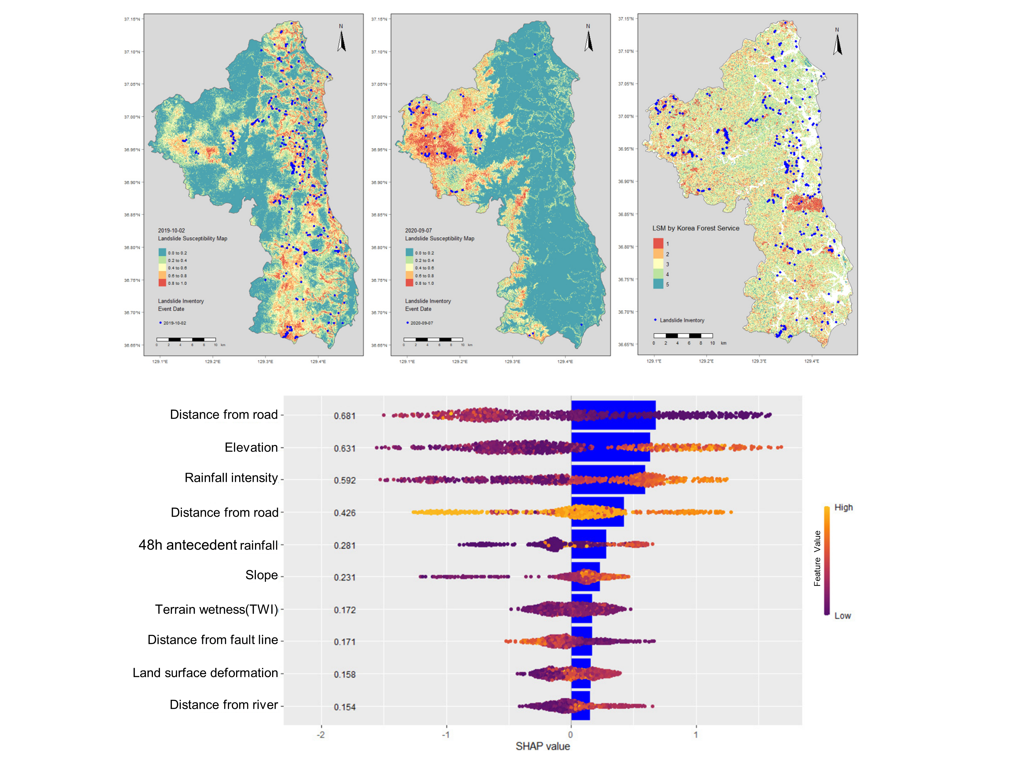
This study presents a machine learning model to predict landslide susceptibility using Interferometric SAR displacement data and Hybrid Surface Rainfall estimates, emphasizing the role of active remote sensing.
The findings highlight the potential of using remote sensing data for landslide susceptibility assessment, offering valuable insights for disaster preparedness and mitigation strategies.
Published in Journal of the Korean Cartographic Association with Dr. Gunhak Lee.
Delayed effects of air pollution on public bike-sharing system use in Seoul, South Korea: A time series analysis
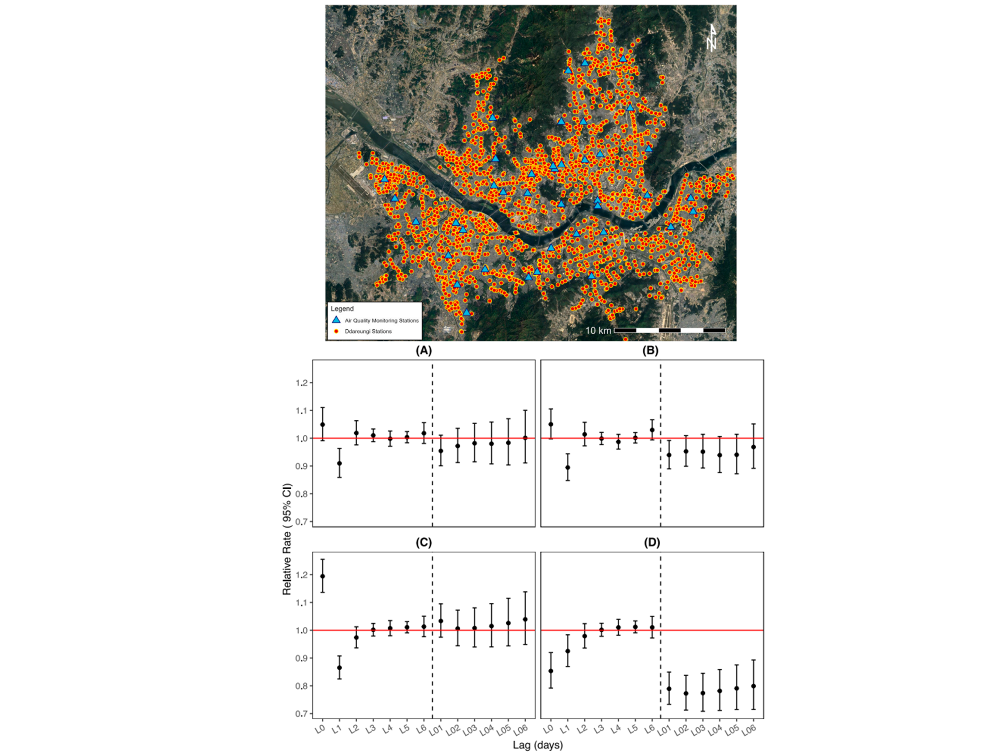
This study examines the short-term impact of ambient air pollution on public bike-sharing system (PBS) usage in Seoul from 2018 to 2021, finding a consistent negative association between elevated levels of air pollutants (PM2.5, PM10, NO2, and O3) and bike usage the following day.
The analysis reveals that high pollution days are linked to a reduction in cycling behavior, with no variations based on age, COVID-19, or seasonality.
Published in Social Science & Medicine with Dr. Eun-Hye Yoo and Dr. John E. Roberts.
Estimation of the de Facto Population at the Building Scale Using a Dasymetric Mapping Method Based on GWR
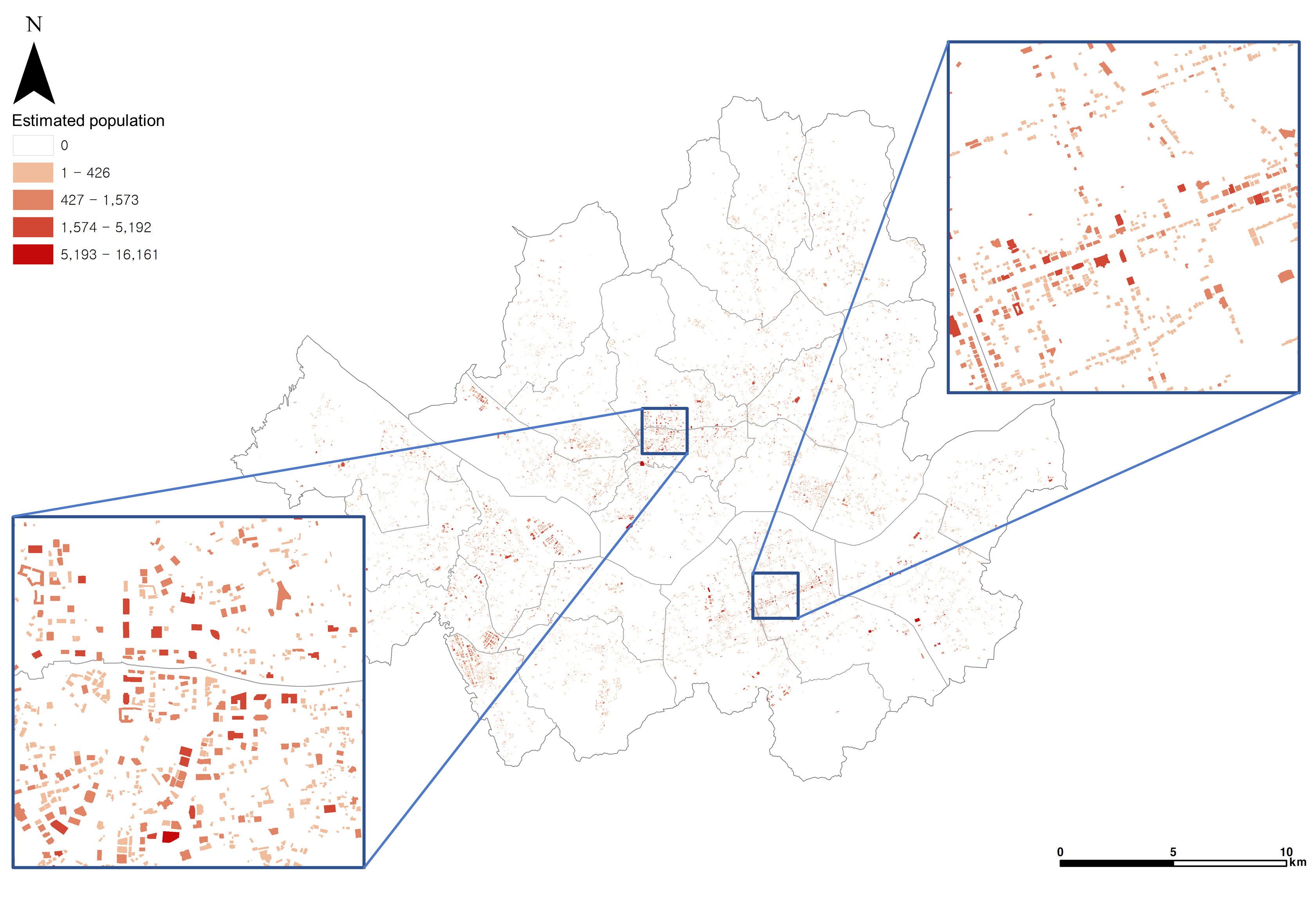
- This study proposes a method using geographically weighted regression(GWR) and dasymetric mapping to estimate fine-scale population in buildings, addressing the challenges of COVID-19 transmission in urban areas.
- By utilizing building usage and floor area as auxiliary data, it provides detailed population distribution estimates for Seoul, which can inform effective pandemic response strategies.
- Published in Journal of the Korean Cartographic Association with Dr. Gunhak Lee.
Accessibility Analysis of Public Cooling Shelters in Seoul Considering Local Temperature: Focusing on the Elderly Population
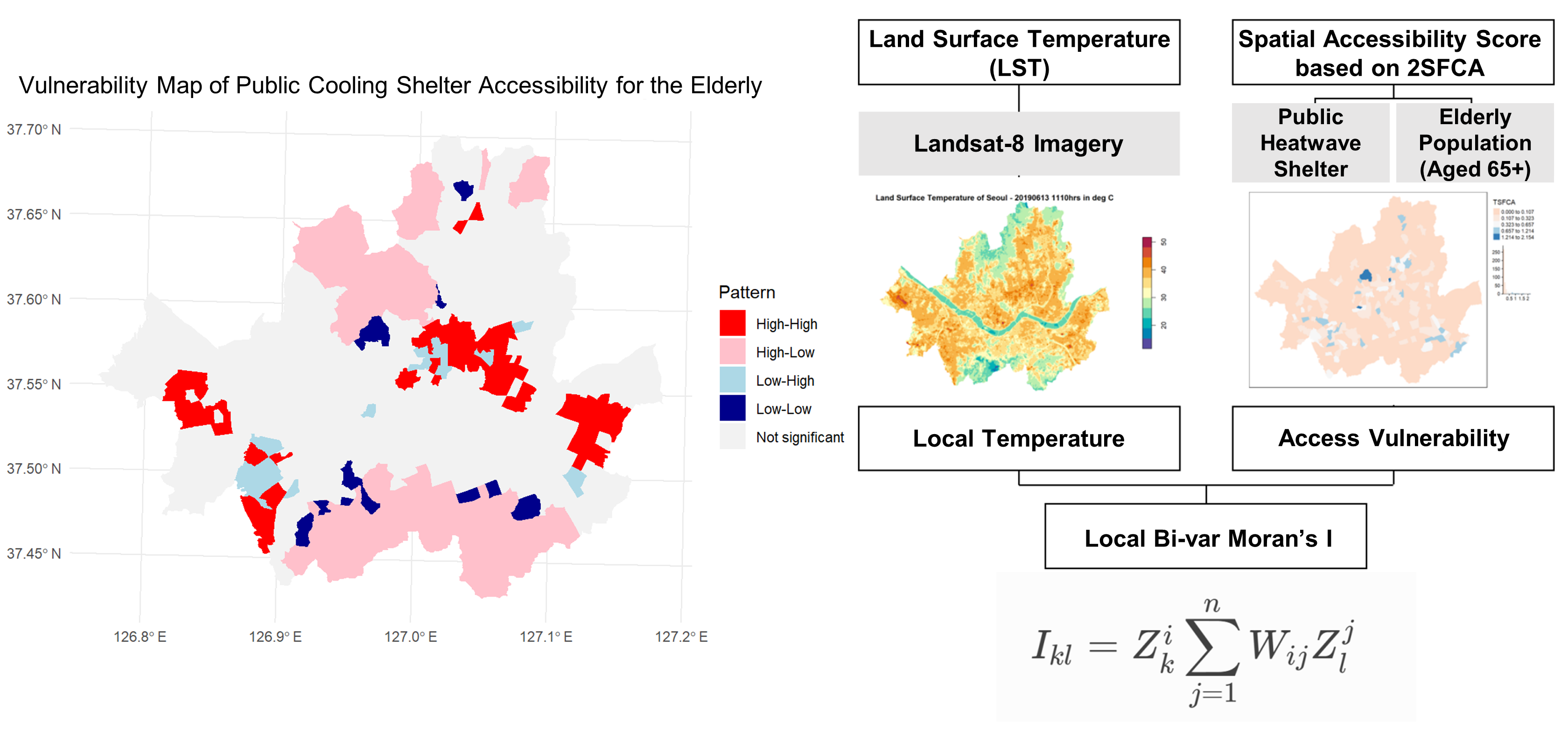
- This study aimed to identify vulnerable areas and inform heatwave policy decisions.
- It examined vulnerability using local Bi-var Moran’s I, analyzing the spatial accessibility of heatwave shelters for the elderly and temperature variations in Seoul.
- The findings were presented at the 2022 Annual Conference of the Korean Geographical Society.
CV
You can either view or download my CV here! 